
Historical Gazetteer
- Ordnance Map
- 5315 Herborn
- Modern Maps
- Kartenangebot der Landesvermessung
- Topographical Maps
- KDR 100, TK25 1900 ff.
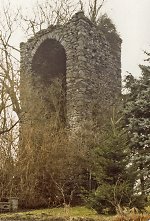


Oberburg Driedorf
-
Burg · 486 m über NN
Gemarkung Driedorf, Gemeinde Driedorf, Lahn-Dill-Kreis
- Settlement ↑
-
Settlement Type:
Burg
-
Localization:
14 km südwestlich von Dillenburg
-
Coordinates:
Gauß-Krüger: 3442270, 5611325
UTM: 32 U 442218 5609521
WGS84: 50.634689° N, 8.182939° O OpenLayers - Statistics ↑
-
Location Code:
53200701014
- Citation ↑
- „Oberburg Driedorf, Lahn-Dill-Kreis“, in: Historisches Ortslexikon <https://www.lagis-hessen.de/en/subjects/idrec/sn/ol/id/14769> (Stand: 15.5.2014)