
Historical Gazetteer
- Ordnance Map
- 4826 Eschwege
- Modern Maps
- Kartenangebot der Landesvermessung
- Topographical Maps
- KDR 100, TK25 1900 ff.
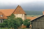


Burg Röhrda
-
302 m über NN
Gemarkung Rohrda, Gemeinde Ringgau, Werra-Meißner-Kreis
- Settlement ↑
-
Settlement Type:
Burg
-
Localization:
9,5 km südlich von Eschwege
-
Castles and Fortifications:
-
Coordinates:
Gauß-Krüger: 3573852, 5663517
UTM: 32 U 573749 5661691
WGS84: 51.101961° N, 10.053328° O OpenLayers - Statistics ↑
-
Location Code:
63601007003
- References ↑
-
Bibliography:
- Cremer, Regierungsbezirke Gießen und Kassel, S. 776.
- Knappe, Burgen in Hessen, S. 68.
- Sammlung Knappe.
- Citation ↑
- „Burg Röhrda, Werra-Meißner-Kreis“, in: Historisches Ortslexikon <https://www.lagis-hessen.de/en/subjects/idrec/sn/ol/id/7587> (Stand: 5.10.2018)