
Historical Gazetteer
- Ordnance Map
- 4621 Wolfhagen
- Modern Maps
- Kartenangebot der Landesvermessung
- Topographical Maps
- KDR 100, TK25 1900 ff.
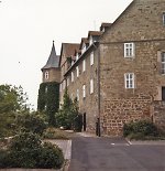

Burg Wolfhagen
-
263 m über NN
Gemarkung Wolfhagen, Gemeinde Wolfhagen, Landkreis Kassel
- Settlement ↑
-
Settlement Type:
Burg
-
Localization:
Im Südwesten der Altstadt von Wolfhagen gelegen.
-
Coordinates:
Gauß-Krüger: 3511632, 5687564
UTM: 32 U 511553 5685729
WGS84: 51.322741° N, 9.165804° O OpenLayers - Statistics ↑
-
Location Code:
63302810054
- Constitution ↑
-
Former Administrative District:
Wolfhagen
- References ↑
-
Bibliography:
- Knappe, Burgen in Hessen, S. 37.
- Sammlung Knappe.
- Siegel, Wolfhagen.
- Citation ↑
- „Burg Wolfhagen, Landkreis Kassel“, in: Historisches Ortslexikon <https://www.lagis-hessen.de/en/subjects/idrec/sn/ol/id/7444> (Stand: 17.2.2014)