
Historical Gazetteer
- Ordnance Map
- 4921 Borken
- Modern Maps
- Kartenangebot der Landesvermessung
- Topographical Maps
- KDR 100, TK25 1900 ff.
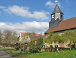


Burg Gilsa
-
209 m über NN
Gemarkung Gilsa, Gemeinde Neuental, Schwalm-Eder-Kreis
- Settlement ↑
-
Settlement Type:
Burg
-
Localization:
Am nördlichen Ortsrand von Gilsa unmittelbar nördlich der Kirche - beim sog. Mittelhof gelegen (An der Kirche [3]).
-
Coordinates:
Gauß-Krüger: 3513483, 5653274
UTM: 32 U 513404 5651453
WGS84: 51.01448° N, 9.191075° O OpenLayers - Statistics ↑
-
Location Code:
63401603003
- References ↑
-
Bibliography:
- Historisches Ortslexikon Fritzlar-Homberg, S. 101-102
- Dehio, Handbuch der deutschen Kunstdenkmäler. Hessen I, S. 323
- Knappe, Burgen in Hessen, S. 91
- Sammlung Knappe
- Citation ↑
- „Burg Gilsa, Schwalm-Eder-Kreis“, in: Historisches Ortslexikon <https://www.lagis-hessen.de/en/subjects/idrec/sn/ol/id/7616> (Stand: 27.3.2013)