
Historical Gazetteer
- Ordnance Map
- 5315 Herborn
- Modern Maps
- Kartenangebot der Landesvermessung
- Topographical Maps
- KDR 100, TK25 1900 ff.
 im Orthofoto")
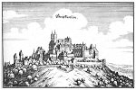


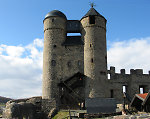
Burg Greifenstein
-
418 m über NN
Gemarkung Greifenstein, Gemeinde Greifenstein, Lahn-Dill-Kreis
- Settlement ↑
-
Settlement Type:
Burg
-
Localization:
13,5 km südlich von Dillenburg
-
Geographical Situation:
Am Südrand des Ortes Greifenstein.
-
Shape:
Burg
-
Coordinates:
Gauß-Krüger: 3450150, 5609687
UTM: 32 U 450095 5607883
WGS84: 50.620692° N, 8.294533° O OpenLayers - Statistics ↑
-
Location Code:
53201004004
- Citation ↑
- „Burg Greifenstein, Lahn-Dill-Kreis“, in: Historisches Ortslexikon <https://www.lagis-hessen.de/en/subjects/idrec/sn/ol/id/15037> (Stand: 15.5.2014)